
Sitemap
A list of all the posts and pages found on the site. For you robots out there is an XML version available for digesting as well.
Pages
Posts
JPM/YPT Montréal Greater Boston Area Bike Tour
Published:
I led a group of around 30 transportation engineers, city planners, and other professionals from Jeunes Professionnels en Mobilité / Young Professionals in Transportation Montréal on a bike tour across the Greater Boston Area. Starting in Boston and biking through Cambridge and Somerville, we explored new cycling infrastructure in these cities. We discussed policies like the Cycling Safety Ordinance by the City of Cambridge and the Safe Streets Ordinance by the City of Somerville, which aim to improve safety and accessibility for all road users, including cyclists and pedestrians. The tour highlighted the impressive progress in cycling infrastructure and how much has changed over the past decade. 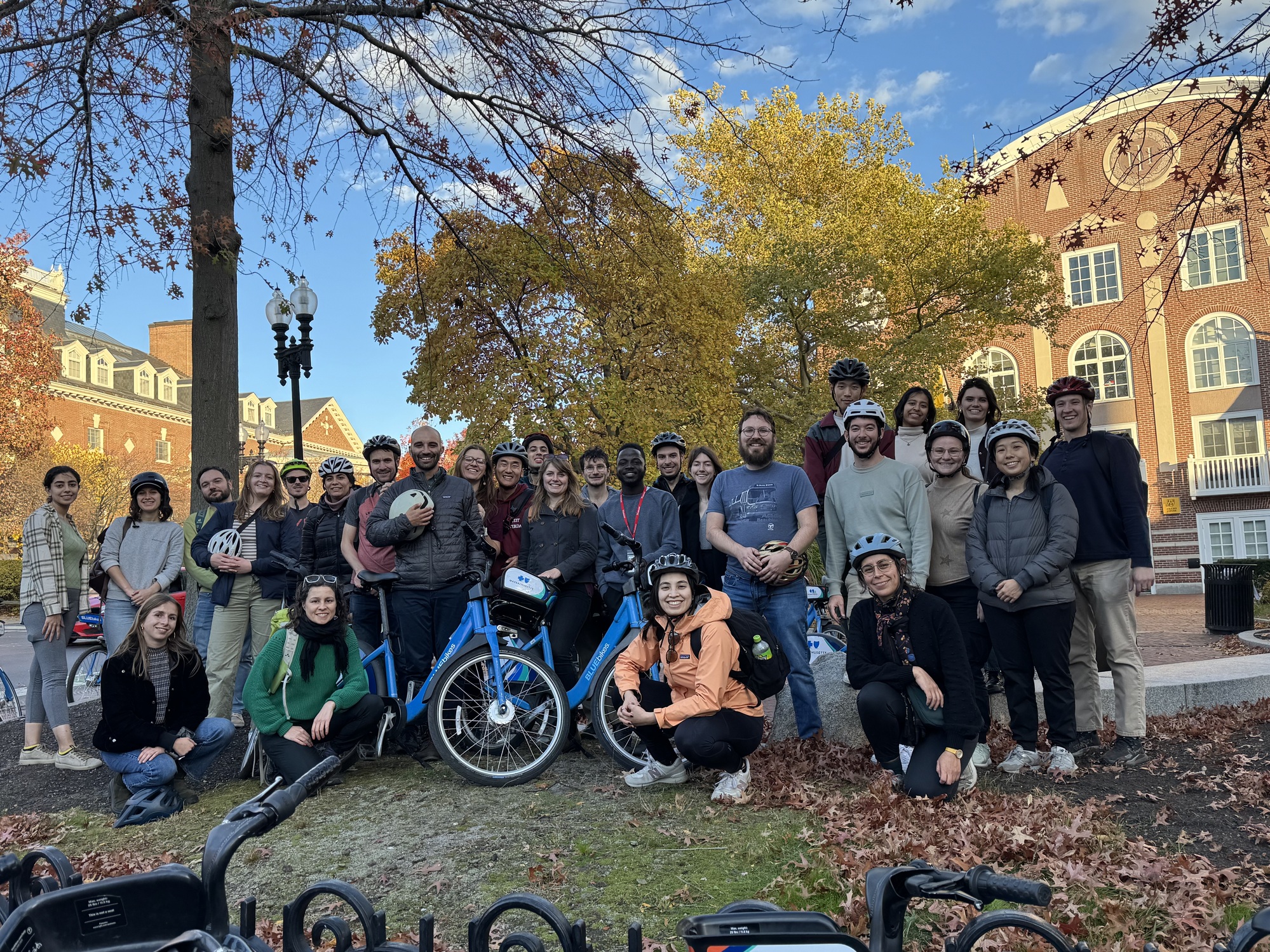
PhD Student Reflects on the Sustainable Transportation Dialogue of Civilizations in Holland
Published:
In my experience during the summer course in the Netherlands, I was deeply inspired by the country’s commitment to sustainable transportation, particularly its cycling culture. The Dutch approach combines innovative infrastructure with a strong emphasis on safety and accessibility, creating an environment where cycling is the norm rather than an exception. This transformative experience instilled in me a renewed sense of responsibility and optimism about reshaping urban transportation in the U.S. to be safer, more sustainable, and inclusive for all users. 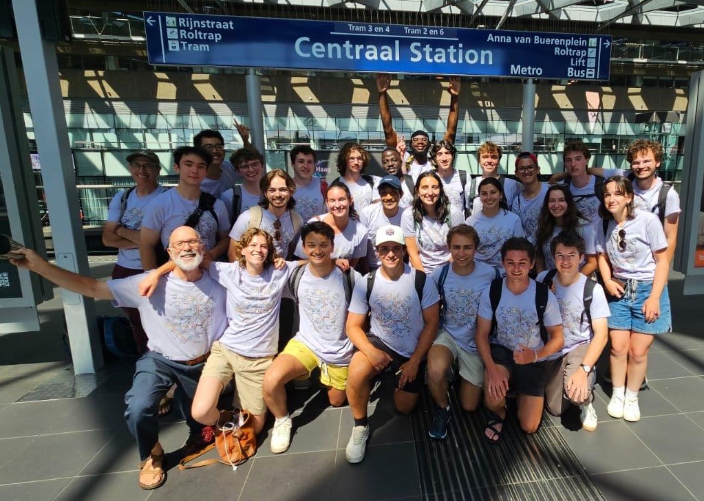
github
Automated Traffic Sign Recognition Using Deep Learning
This project focuses on automated traffic sign recognition using a deep learning model trained on the GTSRB dataset. A Convolutional Neural Network (CNN) is implemented in PyTorch and deployed via a Streamlit web app, allowing users to upload and classify multiple traffic sign images at once. The system provides real-time predictions with confidence scores and displays results in a grid format for easy interpretation.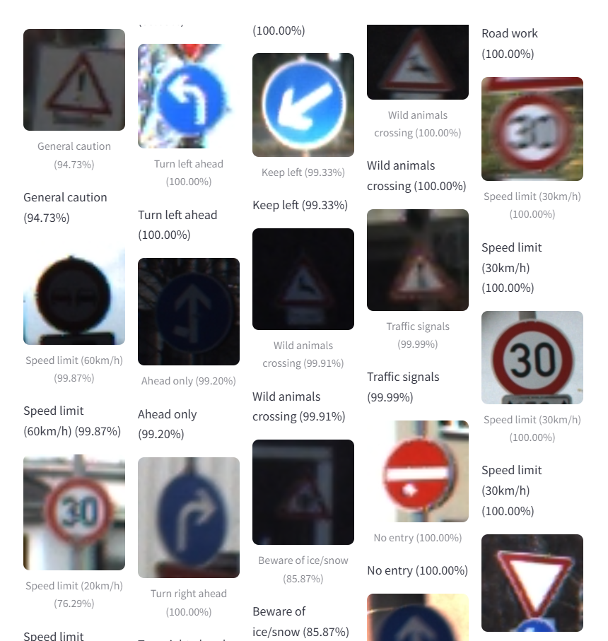
Bicycle Level of Traffic Stress (LTS & xLTS)
Bicycle Level of Traffic Stress (LTS) is a data-driven framework that objectively measures how comfortable a road feels for cyclists, with levels ranging from LTS 1 (low-stress, suitable for most cyclists) to LTS 4 (high-stress, requiring high confidence). Crossing Level of Traffic Stress (xLTS) evaluates the comfort and safety for cyclists at intersections or crossings, considering factors like volume and speed of the traffic being crossed, crossing distance, presence of a bike signal, crossing island, RRFB, etc., to rate the stress level Many cyclists feel anxious about crossing busy intersections, regardless of how comfortable the road segment is. By including xLTS, we can better understand the overall comfort level for cyclists, leading to more informed infrastructure decisions.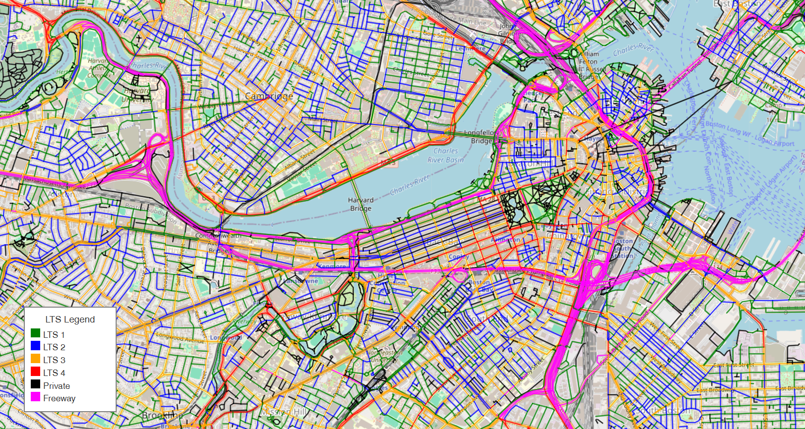
Evaluating the Impact of E-Bike Integration on BlueBikes Ridership Patterns Using Machine Learning and Computer Vision
The introduction of electric bikes to Boston’s BlueBikes system has likely altered trip dynamics, including trip durations, demand patterns, and station usage. This analysis explores the impact of e-bikes on these factors, focusing on differences in trip lengths, popular routes, station turnover, and mode choice between electric and traditional bikes. By comparing e-bike trips with traditional bike trips, the goal is to understand how e-bikes influence overall system performance, user behavior, and mode preferences. These insights will help inform strategies for optimizing bike distribution and enhancing the efficiency of the bike-sharing system.
Multi-User Sleep Tracker
I created a multi-user web app that lets each user log in with a unique username and record their sleep sessions. All entries—start and end times, duration, and comments—are automatically saved in the browser’s Local Storage under that username. The app also generates a daily total sleep chart using Chart.js, providing an at-a-glance visualization of sleep patterns. Users can edit or delete existing records and export or import their data as JSON files, making it easy to back up or transfer. This simple, self-contained tool helps maintain ongoing sleep logs without needing a server or database.
Four Rooms Reinforcement Learning Problem
The Four-Room Reinforcement Learning (RL) problem is a classic grid-world environment where an agent navigates through four interconnected rooms, separated by narrow doorways. The agent must learn optimal policies to reach a goal state from any starting position, using actions like moving up, down, left, or right. The problem is designed to challenge exploration and learning efficiency, as the agent encounters varying rewards and obstacles, requiring it to balance exploration and exploitation while navigating through a structured, partitioned space.
portfolio
Underlying Traffic Signal Control: The Key to Effective Transit Signal Priority: A Case Study of MBTA Bus Route 39 along South Huntington Avenue, Boston, MA
On Route 39, the MBTA’s fourth-busiest bus route, buses experience an average delay of 43 s at the Perkins and Bynner Street intersections along South Huntington Ave. While simply implementing Green Extension, a Transit Signal Priority (TSP) tactic, alone provides limited bus delay reduction, combining it with a TSP-friendly signal control logic and a TSP-friendly intersection layout cuts the delay down to just 5 s. This strategy also reduces pedestrian wait times by more than 60%, without sacrificing bike lanes or parking. Microscopic traffic simulations using PTV Vissim reveal that this smart approach does not even increase auto delay.
Accessible Bus Stop Design in the Presence of Bike Lanes
Floating bus stops, adjacent to bike lanes, require bus passengers to cross the bike lane to board or alight, creating challenges, especially for visually impaired and wheelchair users. This study examined different floating bus stop designs in Greater Boston, analyzing rider behavior and conflicts with bicyclists, and provides design recommendations to improve accessibility and safety.
publications
Modification of Bitumen with Waste Materials for Enhanced Aggregate Retention in Surface-Dressed Roads
Published in 3rd IRF Africa Regional Congress & Exhibition, 2023
Raveling, the loss of aggregate from surface dressing, poses significant maintenance challenges and economic burdens for road agencies, especially in developing countries. This study explored the use of locally available waste materials, such as ground-tire rubber (GTR), as sustainable bitumen modifiers to mitigate raveling, finding that GTR-modified bitumen significantly reduces aggregate loss under adverse conditions, making it a viable alternative for improving chip seal performance.
Accessible Bus Stop Design in the Presence of Bike Lanes
Published in Office of Transportation Planning, Massachusetts Department of Transportation, 2024
Floating bus stops, adjacent to bike lanes, require bus passengers to cross the bike lane to board or alight, creating challenges, especially for visually impaired and wheelchair users. This study examined different floating bus stop designs in Greater Boston, analyzing rider behavior and conflicts with bicyclists, and provides design recommendations to improve accessibility and safety.
Assessing the Impact of Electric Bikes on Urban Mobility: A Case Study of Boston’s Bluebikes
Published in GitHub Repository, 2024
I conducted a detailed analysis of Bluebikes (the public bike share system in the Metro Boston area) data to understand how the introduction of electric bicycles influences transportation choices and urban dynamics. By applying various statistical models, I assessed the shifts in demand for public bike-sharing systems, examining factors such as user preferences and usage patterns.
XGBoost-Driven Demand Prediction for Optimized Electric Vehicle Charging Recommendations
Published in GitHub Repository, 2024
Developed an integrated framework combining predictive modeling and optimization techniques to enhance the efficiency of electric vehicle charging infrastructure. Leveraged the Adaptive Charging Network dataset from Caltech, containing extensive charging session logs and other relevant data.
Sign-Aware Attention-Based Multitasking Framework for Integrated Traffic Sign Detection and Retroreflectivity Estimation
Published in Expert Systems with Applications, 2025
We propose SAAM-ReflectNet, a deep learning framework that automates traffic sign detection, classification, and retroreflectivity estimation by integrating robust spatial-semantic feature extraction, Sign-Aware Attention, and multimodal fusion of RGB and LiDAR data. Achieving a mean Average Precision (mAP) of 0.635 and RMSEs of 0.169 (foreground) and 0.147 (background), ReflectNet demonstrates scalability and accuracy, making it ideal for large-scale, proactive traffic sign maintenance.
Design Guidelines for Accessible Floating Bus Stops
Published in ASCE International Conference on Transportation and Development, 2025
This paper summarizes global best practices for integrating separated bike lanes with bus stop infrastructure, analyzes bicyclist and transit rider behavior at various floating bus stops to understand their interactions, and develops design guidelines to improve the safety and accessibility of floating bus stops.
Download Download Slides
</p>TSP-Friendly Underlying Traffic Signal Control, An Essential Complement of Transit Signal Priority
Published in Future Transportation, 2025
Transit Signal Priority (TSP) can reduce bus delays, but in the U.S., the reductions are often small due to TSP being applied within traffic signal systems not optimized for it. TSP-friendly signal control involves minimizing bus phase red times and adjusting green phases to match bus arrivals. Simulations in Boston showed that combining active TSP with TSP-friendly control reduced bus delay 2.0 to 3.1 times more than applying TSP over existing systems, with delays dropping to under 5 seconds at two sites.
teaching
CIVE 2222: Recitation for Statics & Solid Mechanics
Undergraduate course, Northeastern University, Boston, MA, 2023
Tutored fundamental concepts of Newtonian physics to practical applications in solid mechanics, equilibrium of particles and rigid bodies in various dimensions, internal forces in trusses and frames, creation of shear and moment diagrams for beams, and computation of stresses induced by various forces, moments, and torque.
CIVE 4554: Highway Design
Undergraduate course, Northeastern University, Boston, MA, 2025
Tutored practical applications of AutoCAD Civil 3D for highway design projects, including horizontal and vertical alignment creation and editing, corridor modeling and assembly design, earthwork calculations and grading optimization, profile and cross-section generation, superelevation analysis and application, and quantity takeoff reports for construction documentation.
CIVE 5373: Transportation Systems Analysis and Planning
Undergraduate course, Northeastern University, Boston, MA, 2025
Graded assignments covering urban transportation modeling and policy analysis, including travel demand forecasting and four-step modeling processes, traffic flow theory and capacity analysis, mode choice analysis and transit planning strategies, land use and transportation integration, network optimization and route assignment methods, and evaluation of transportation projects through economic and environmental impact assessments.
CIVE 5520: Energy Systems: Science, Technology, and Sustainability
Undergraduate course, Northeastern University, Boston, MA, 2026
Provided grading support for coursework examining the scientific, technological, and economic aspects of modern energy systems and sustainability challenges. Led discussions on principles of energy, work, and thermodynamics, covering energy supply and demand technologies including fossil fuels, nuclear power, and renewable sources (wind, solar, hydro, geothermal, biofuels). Helped students understand energy transmission and distribution systems, efficiency technologies across buildings and transportation sectors, and sustainability concepts including life-cycle assessment, energy-related emissions, and net-zero energy facilities.
CIVE 5376: Traffic Engineering and Sustainable Urban Street Design
Undergraduate course, Northeastern University, Boston, MA, 2026
Evaluated assignments on intersection analysis and design including traffic flow theory and measurement, capacity analysis, queuing and delay for vehicles and pedestrians, and signal timing plan design. Assisted students in applying street design principles covering street functions, speed control, street and intersection layout, bicycling facilities (bike lanes and separated paths), and pedestrian facilities (sidewalks and crossings) to balance traffic capacity, safety, walkability, bikeability, and quality of public space.
CIVE 4566: Design for Sustainable Transportation: Netherlands
Study abroad program, Technische Universiteit Delft, The Netherlands, 2026
Assisted in teaching Vision Zero traffic safety principles and design treatments for safe roads, intersections, and crossings; and high-quality transit service planning and design. Other topics explored are traffic-circulation planning and policies to promote safety, prevent roads from becoming barriers to walking, cycling, or transit, and to create car-free and car-lite zones.